
Batcombe update - 16 February 2026
The field has recently been ploughed and will likely be cropped in the near future. The parking area just inside the gate is now extremely restricted and will only take 3 to 4 cars if parked sensibly. If you are forced to park elsewhere please do not block gates.
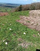
Like the parking area, launch has been restricted to a small patch of grass at the edge of the ploughing line. The ploughed area has a large number of sharp flints that will snag, and potentially damage lines.
Once the crop grows to a certain height it will be impossible to top land so expect to have to bottom land if using the site later in the spring/summer.
The site is still useable with care but an alternative NW site is available at Bell Hill (Wessex HGPG)

Batcombe (Telegraph Hill)
SITE TYPE | Hill | LOCATION | 50.844 / -2.51 | |
SITE ACCESS | MEMBERS ONLY | GRID REF. | ST641050 | |
PILOT RATING | CP | TAKE OFF | ||
WIND DIRECTION | WNW - NNW | PARKING | ||
BEST | NW | HEIGHT | 837 feet (255m) | |
XC POTENTIAL | GOOD | TOP - BOTTOM | 263 feet (80m) |

Site Rules
-
Strictly Condors members only (landowner request)
-
Closed 1st September to 31st January for pheasant shooting
-
Intention to fly must be posted on the Batcombe Telegram group
-
Ensure all gates are closed. Livestock is often present
-
Parking is permitted just inside the field if conditions permit. Do not attempt to enter if the field is wet
Hazards
-
Trees either side of launch - rotor on launch especially if the wind is off
-
Scratching low over the tree covered slope - move out early if getting low
-
Top landing needs careful assessment of conditions - avoid landing behind the trees
-
There is no way to launch down the slope and you will therefore be bringing the wing up in the venturi. Make a careful assessment of wind speed and direction before inflating.
About
Batcombe is a small, largely tree covered hill site with a narrow take off between trees. The site is often thermic and offers the potential for XC flights towards Wareham and Swanage. The site is closed for pheasant shooting from 1st September to 31st January each year.
Batcombe is open to all level of pilots and is rarely crowded however it is not ideally suited to LATs who would probably find Bell Hill (Wessex HGPG) more forgiving on a NW day.
On summer days Batcombe can be affected by sea breeze early in the day.

Access & Parking
From the North:-
From Yeovil take the A37 south towards Dorchester and after approx. 7 miles take a left turn signposted Batcombe and Minterne Magna.
Follow this road for a couple of miles, continue approx ¼ mile past a left turn signposted “To the Friary / Hilfield / Batcombe” and as you emerge from the wood there is a large grassed/mud lay-by on the left with two gates.
https://what3words.com/adopters.nails.pickup
From the South:-
Take the A37 north from Dorchester to Yeovil and turn right at the signpost for Batcombe and Minterne Magna after about 7 miles, just after passing the white "golf ball" water tower and the Southern Counties Clay Shooting park and then continue as above.
If conditions are dry enough, enter the right hand gate (one with a footpath marker) and park inside on the right under the trees against the hedge line. Park in a position that doesn't block the gates or the gap as the farmer may need to get a tractor and equipment through. Walk across the field along the ridge to the take-off in the clearing between trees and adjacent to a barbed wire fence that runs up the hill.
If the field is wet assess the conditions before driving in and park elsewhere if there is a danger of damaging the surface. If parking in the lay-by ensure there is sufficient space for farm machinery to use both gates.
Guidlines
Assessing true wind direction can be difficult as the wind comes up the hill between the trees on either side. If the wind is off in either direction the trees will produce rotor across the launch area making it difficult to reliably inflate a wing.
There is a small drop off at the edge of take off (marked red in the photo). Raise the wing on the flat area behind this and walk towards the edge. You should be airborne before reaching the drop off. If not then you should consider aborting the launch and re-assessing wind direction and strength.
Be prepared to actively fly the wing immediately on take off due to the danger of encountering rotor from the trees.

Do not linger in front of launch to allow other pilots to take off. Pilots taking off may not be able to see pilots scratching low if they are behind the trees to the North of take off. Be prepared to take avoiding action.
Avoid the temptation to scratch low over the trees. Pilots have been caught out by patches of sink on a number of occasions that dump them into the trees and it is extremely difficult to recover the pilot and their equipment.
Bottom Landing
Any of the fields in front of take off are suitable to bottom land. If animals are present please try to land in another field or as far away as possible from the livestock.
The fields on the Northern half of the site have trees downwind and may be in rotor. Use caution if landing these and try to avoid having to use them.
There is a wide track back up the hill that brings you out near the field entrance and a smaller path that brings you out back on launch. It is possible to go straight up the face in front of launch but it is very steep in places and partially overgrown.

Top Landing
Be prepared to encounter rotor anywhere across the top landing field. Land well back from the trees and preferably in line with the launch gap. Get your feet down early and be ready to actively fly all the way to the ground.
Careful consideration will need to be given to the landing approach if already low as it may not be possible to avoid rotor in which case it would be better to bottom land.
Do not land directly behind any of the trees
Slope landing just below take off is possible but extremely tricky and best avoided especially if pilots are trying to launch.
If in any doubt bottom land
XC Potential
Excellent - Pilots have flown from Batcombe to the other side of Salisbury, Swanage, and Kimmeridge etc.
Try not to land in the Minterne Estate (large country pile immediately downwind).
Airspace
There are a number of airspace regions along the main downwind track and it is essential for pilots to ensure they are able to navigate using their instruments to avoid infringing any of these.
In particular DO26 LULWORTH should be avoided as this is a live fire area. It is possible to overfly this area if the ranges are not active however you should not land due to the presence of unexploded munitions.

All pilots using Devon & Somerset Condors HGPG sites must be current BHPA flying members, hold a minimum rating of CP Hill and obtain a site brief from a pilot who regularly flies the site.
The information contained in this document is provided purely as guidance. It is not intended to be an exhaustive guide to the hazards that may be encountered and it is the responsibility of individual pilots to carry out their own assessment of the site and weather conditions before making a decision to fly.
Neither the Devon & Somerset Condors Hang Gliding and Paragliding Club, authors of this guide, editors of this guide, any official or member of the club in any way accept liability for any accident, injury, or loss, to any person, resulting from free flying activities or the use of this guide.